Researchers at the University of Minnesota Twin Cities have developed an advanced, multi-view drone swarm system that can capture the complex, three-dimensional dynamics of wildfire smoke plumes in real time.
The innovation, recently published in Science of the Total Environment, has the potential to significantly improve fire management strategies, air quality predictions, and public safety during both wildfires and prescribed burns.
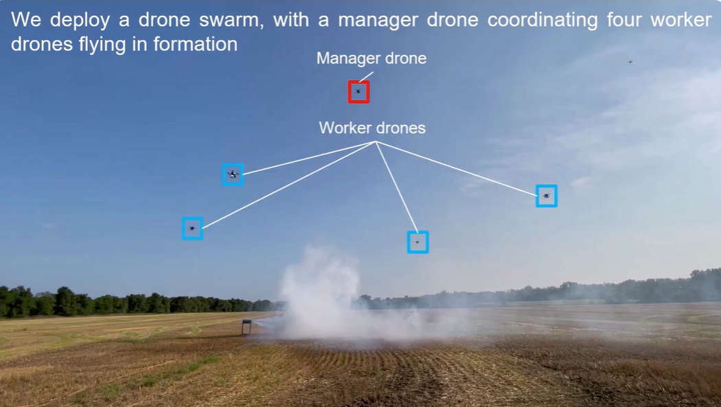
The system consists of a manager drone and four worker drones, each equipped with high-resolution cameras and GPS modules. Using image feedback, the manager drone autonomously positions itself above a smoke plume, coordinating the worker drones to orbit in a synchronised circular pattern.
This formation captures multi-angle images, which are then processed using Neural Radiance Fields (NeRF) to generate detailed 3D reconstructions of plume dispersion at a temporal resolution of about one second.
Field tests demonstrated the drones’ ability to track key plume characteristics such as volume, wind-driven shifts, and lofting behavior. Unlike traditional remote sensing or Lidar tools, which struggle with mobility and temporal resolution, this drone swarm provides highly adaptable, cost-effective coverage – even in difficult terrain.
Nikil Nrishnakumar, a graduate research assistant with the Minnesota Robotics Institute at the University of Minnesota and first author of the paper added: ‘This approach allows for high-resolution data collection across large areas – at a lower cost than satellite-based tools. It provides critical data for improving simulations and informing hazard response.’
The need for such innovation is urgent. Between 2012 and 2021, 43 wildfires were sparked from 50,000 prescribed burns in the U.S., underscoring the risks of poor smoke management, according to an Associated Press report.
Existing simulation tools like FIRETEC and QUIC-Fire attempt to model fire and smoke particle behavior but lack accurate validation due to limited real-world 3D data.
Jiarong Hong, professor of mechanical engineering at the University of Minnesota and senior author of the paper said: ‘A key step is understanding the composition of smoke particles and how they disperse. Smaller particles can travel farther and stay suspended longer, impacting regions far from the original fire.’
Beyond wildfire management,’ characterisation and deploying fixed-wing VTOL drones for extended-range surveillance.
‘Early identification is key,’ Hong emphasised. ‘The sooner you can see the fire, the faster you can respond.’

Leave a Reply