From sidewalks to satellites: ‘unprecedented’ air quality investigation launched in the US
A scientific investigation enormous in ‘scope, scale and sophistication’ has been launched to take what essentially amounts to a nationwide census on air pollution in North America.
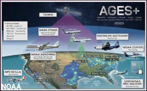
Scientists from the National Oceanic and Atmospheric Administration (NOAA), NASA and 21 universities from three countries will be using satellites, seven research aircraft, vehicles and stationary installations to investigate how air pollution sources have shifted over time.
‘No one agency or university could do anything like this alone.’ said NOAA Administrator Rick Spinrad.
David Fahey, director at the Chemical Sciences Laboratory (CLS) added: ‘The large number of participants, measurements, the variety of platforms involved, and the way they are working together in a highly choreographed and coordinated way is unique. Our goal is a comprehensive view of air pollution spanning the U.S. to improve forecasts of urban and regional air quality and advance the health of our nation.’
Pollution sources that include transportation, industrial facilities, agriculture, wildfires and consumer products such as paint, pesticides and perfume will be examined with particular attention being paid to ground level ozone and PM2.5, which between them are responsible for more than more than 100,000 Americans dying prematurely every year.
The data will be run through sophisticated chemical and weather models by scientists and the U.S. Environmental Protection Agency (EPA) in an effort to improve air pollution forecasts. Findings will be shared with state and local environmental officials to inform decisions about the most effective ways to reduce air pollution.
Some of the constituent parts of the overall project include – and we’re about to get knee-deep in acronyms here: AEROMMA (Atmospheric Emissions and Reactions Observed from Megacities to Marine Areas) will collect data using NASA DC-8 research aircraft to identify ‘emerging research needs in urban air quality, marine emissions, climate feedbacks, and atmospheric interactions at the marine-urban interface.’
STAQS (Synergistic TEMPO [Tropospheric Emissions: Monitoring Pollution] Air Quality Science) will integrate high-resolution satellite measurements with traditional air quality monitoring to ‘improve understanding of air quality science and increase societal benefit’ This will primarily focus on New York and Los Angeles.
As part of SCILLA (Southern California Interactions of Low cloud and Land Aerosol) Experiment, a research aircraft was sent to San Diego in June (the month of climatological maximum low cloud cover). Data collected here will compliment EPCAPE (Eastern Pacific Cloud Aerosol Precipitation Experiment).
On the ground, researchers from Yale University, Aerodyne Research Inc. and other NOAA-funded collaborators will be taking measurements from a rooftop site at the The City College of New York campus, downwind in Guilford, Connecticut, from a 62m tall research tower on Long Island.
Yale Professor Drew Gentner, who is coordinating the ground sites in New York and Connecticut, explained: ‘This regional network of ground sites has enormous potential to help us understand urban and downwind air pollution — not just today but under a continually changing climate.’
Carsten Warneke, another CSL scientist, summed up the whole project: ‘In order to make progress on reducing air pollution that negatively affects millions of Americans, we need to have a better understanding of the current sources of pollutants and what happens to these pollutants once they are in the atmosphere.’
We await the results with interest.
