Noise maps published by Welsh Government
The Welsh Government has published a series of online maps to illustrate levels of noise from traffic, rail and industry across Wales
A series of interactive online maps showing estimated levels of noise from traffic, rail and industry in Wales were published by the Welsh Government yesterday (February 25).
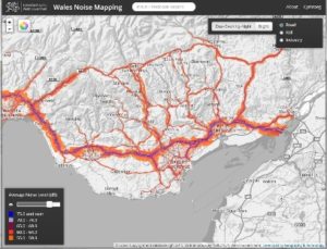
The noise maps show average estimated levels of noise in Wales’ three largest urban areas — Swansea, Cardiff and Newport — as well as noise from the busiest roads and railways across the country.
Those who view the maps online are able to switch between estimated noise levels in decibels (dB) at night and during the day time, with the map generally showing higher levels during the day than at night.
The highest levels of noise from traffic are shown in South Wales on roads connecting Newport, Cardiff and Swansea. The M4 motorway in particular is shown with day time levels at 75.0 dB and higher. The A55 road in North Wales connecting Chester and Bangor also shows similar noise levels.
South Wales also has the highest levels of noise from rail, with the line running from Bristol to Swansea showing levels as high as 75.0 decibels or more.
Almost all mapped railway lines are due to be electrified and the Welsh Government is currently considering the possible improvements in noise levels resulting from this.
Industry noise hotspots also appear on the map in South Wales as levels calculated in Newport and Port Talbot reach 75.0 dB or higher.
Calculated noise
However, noise levels on the map are calculated rather than measured. As a result, according to the Welsh Government, the maps are based upon some assumptions and “should not be relied upon to tell how noisy it really is outside specific properties”.
Calculations for the Welsh noise maps were completed by government consultants in June 2012 with the results reported to the European Commission in December 2012 as part of requirements in the Environmental Noise Directive (2002/49/EC).
According to the Welsh Government, the maps are designed so that local authorities and other organisations can identify where high levels of noise coincide with other social and environmental problems. They will then be able to address these issues to improve the quality of life for people living and working in their areas.
Welsh Government environment minister, John Griffiths, said: “One of my top priorities is to improve the local environment for people living in our most disadvantaged areas. Noise pollution should be treated with particular seriousness when it coincides with other factors such as poor air quality, low housing standards and lack of green space.”
The noise maps are being used to help the Welsh Government develop and implement a noise action plan to bring together the noise policies and priorities of public authorities across Wales. This is due to be consulted on and published in 2013.
The noise maps are available to view on the Wales Noise Mapping website.


