


Managing levels of PM2.5 from wood burning smoke emissions through combined air quality modelling, real-time sensor measurements, and data services.
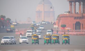
Air quality and the dangers of high concentrations of ambient air pollution is of growing concern within day-to-day life. With remote working still in place for most of the country together with colder winter temperatures, it is inevitable that the usage of domestic burners and open fires increases, contributing to a rise in local levels of particulate matter (PM2.5), a pollutant which can contribute to and worsen health problems including COPD, diabetes, and asthma.
Identifying and mitigating PM2.5 emissions from activities including wood burning stoves, open fires, bonfires, waste burning and restaurants, may be the transforming factor that enables large scale improvements in public health.
This is an area that the air quality specialist, EarthSense, has been supporting as part of a cutting-edge project with Leicester City Council, which utilises their full air quality monitoring service including sensors, modelling and guidance. This system is designed to clearly communicate the consequences of burning wood at specific times and places for the residents of Leicester.
To do this, a collection of data was used to feed into the model, including Computational Fluid Dynamics (CFD) for calculations of how pollution flows throughout urban canyons and buildings in Leicester, source apportionment to identify each of the particulate matter sources, a traffic layer as well as a wood burning smoke estimate created by EarthSense for the Council.
Leicester City Council also used MappAir®’s historic pollution data and up to three-day air quality forecasting, which was used to notify members of the public of days predicted to experience unsafe levels. The highest concentrations were measured on cold days likely to increase usage of log burners or public celebrations such as bonfire night. The EarthSense solution is designed to deliver guidance in advance of high pollution events, and behavioural changes for personal and community benefit.
For a real-time, local understanding of local PM2.5 emissions, the project also uses EarthSense’s flagship product, the Zephyr® sensor with an established network of 11 units including 6 static units around Leicester, 1 outside the city boundary together with mobile units connected to electric vehicles and bicycles.

The combination of both mobile and static sensors with the MappAir® city model provides an everyday analysis of large-scale areas and locations of interest along with detailed pollution data for hotspots; all of which are integrated with the pollution map for additional context into how wood burning smoke impacts air quality in Leicester.
Utilising this analysis, the project sees domestic smoke emissions highlighted through a collection of EarthSense’s monitoring tools, and the contribution of such activities to increased PM2.5 levels can be quantified. Data is also ready to view via EarthSense’s MyAir® web app where wood burning smoke emissions are collated and can be analysed before delivering evidence-based advice to the residents of Leicester.
Speaking to Air Quality News about the project, EarthSense Technical Director, Dr. Roland Leigh said “Burning of solid fuels in homes has been a fundamental component of domestic management for centuries and is practiced across the world. However, we now understand the health damage which can be caused, both within the property and to neighbouring communities. This project offers a critical solution to local authorities and the public, through clear identification of the most important moments to manage emissions, and communication of potential health impacts of any burning activities. Such guidance, enabled by the full stack of EarthSense technologies, offers a more manageable solution where long-term infrastructure and behavioural change is required. ”
Through making use of EarthSense’s complete air pollution monitoring service, Leicester City Council have proven how leading hardware, software and data provision can reduce health risks within their community. By taking early measures to manage particulate matter emissions and highlighting days likely to experience unsafe levels through advising members of the public, the council encourage local changes in day-to-day behaviour. Leicester City Council also have future plans to create an interactive map and mobile phone app to deliver guidance surrounding wood burning risks, providing easily accessible data directly to the residents of the city.
For further information: +44 (0)116 296 7460 / info@earthsense.co.uk
Download our free case study & learn how business are using MappAir modelled data alongside Zephyr sensors data to improve air quality.
Leave a Reply